 |
| Kali Garang taken from the Jatibarang Dam in 2016. The Kali Garang was the main water sources for Kali Semarang. |
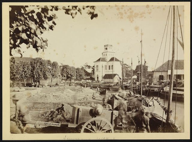
Kali Semarang was a river that divides the city of Semarang, a branch of Kali Garang (Eng: Garang River) from the west part of the city and flows to the Java Sea. The development of Semarang City was really depends on Kali Semarang, as the major commerce hub of the inner city of Semarang since centuries ago. One of the traces was the toponym of Kampung (Eng: village) along Kali Semarang which is an age marker of its vital role for commercial activities for Semarang City. One of them was Kampung Pabean which is now part of the Kecamatan Semarang Utara areas. In this Kampung, used to be the location of customs/ tax posts for the boat which passing through Kali Semarang to trades in the hinterland of Semarang City. There’s a fun fact that on that time where customs post was marked by a large tree trunk that was chained and floated across the river as a barrier in the river flow. This is where the name of Boom Lama was coming from, as the word Boom in Dutch means tree, refers to the tree trunk that has a functions as the entrance gate. The name of Boom Lama still used today as the name of one of the major roads not far from its location.
 |
| Kali Semarang taken from the opposite of Dokter Djawastraat, nowadays Jalan Kol. Sugiono, nearby Kampung Melayu Semarang in 1900. (Source: Leiden University Library) |
We have to remember that the Semarang city at that
time was way smaller than the condition nowadayas. The city of Semarang on 18th
century was refers to the part of the city that now called as Kawasan Kota Lama Semarang, an area
which is developed from the VOC base which was established in the Sleko area in
1705. This trading post was surrounded by a defensive wall which had five
bastions, which later well known as Vijfhoek
fortress which means a pentagon. In 1748, due to the increasing commerce activity in Semarang, the VOC main base in Batavia, nowadays Jakarta raised the
status of the leader of its trading post in Semarang into governor and its
became the center of the area of the Noordoostkust
(eng: North East Coast) of Java region. Vijfhoek as the main base of the VOC in
Sleko then became unable to accommodate more European migrants, until later
this settlement expanded rapidly. It was unknown exactly when European settlers
began to organize the area outside Vijhoek as settlement but referrings to the Atlasof Mutual Heritage website, its shows that in 1787 a plan was made to expand
the city defensive wall complete with urban arrangement with road networks and
various facilities such as church, military barracks, health service
facilities, civil service facilities, etc. Interestingly, the road network and
the parcels of land were almost unchanged, compared to the current conditions
with this map that comes from the past three centuries.
 |
| The Groot Boom with the boat tethered on the edge of Kali Semarang taken from the high stories of Uitkijk, ca. 1870-1910 (source: Rijksmuseum) |
 |
The schutsluis (locks) that connected Kali Semarang and Kali Baru in 1927.
(Source: Leiden University Library)
|
 |
| Nieuwe Kanaal also known as Kali Baru, the new canals that also became part of Port of Tanjung Mas Semarang, taken from the top of Willem III Lighthouse in 2017. |


